Направо към съдържанието

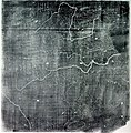
Файл:Song Dynasty Map.JPG

Съдържанието на страницата не се поддържа на други езици.
от Уикипедия, свободната енциклопедия

Оригинален файл (756 × 768 пиксела, големина на файла: 436 КБ, MIME-тип: image/jpeg)

Емблемата на Общомедия Този файл е от Общомедия и може да се използва от други проекти.

Следва информация за файла, достъпна през оригиналната му описателна страница.

Info

Описание

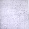
The Chinese Yu Ji Tu (Map of the Tracks of Yu the Great), a map carved into stone in the year 1137 during the Song Dynasty, located in the Stele Forest of modern-day Xian, China. Yu the Great refers to the Chinese deity described in the Chinese geographical work of the Yu Gong, a chapter of the Classic of History. Needham and Chavannes assert that the original map must have predated the 12th century.

The graduated scale of this gridded map is at 100 li (Chinese mile) squared for every representative square in the grid. The overall size of the map is 3 ft squared. The coastal outline is relatively firm and the precision of the network of river systems is incredibly accurate. The name of the geographers and cartographers who initially created the map are unknown. In the year 1142 a copy of the map was preserved at Zhenjiang in Jiangsu province by a certain Yu Chi, who was then a Prefectural Director of Studies. There is also mention of an earlier copy of about 1100 AD which itself was based on the Chang'an version. Needham asserts that the map was used primarily to instruct students while referring to sites described in the ancient Yu Gong chapter of the Classic of History.
Дата printing of a rubbing of a c. 1136 engraving of a c. 1100 map
Източник Joseph Needham's Science and Technology in China, Vol. 3: Mathematics and the Sciences of the Heavens and the Earth, Plate LXXXI and text description pp. 547–549, hardback edition
Автор Unknown, photo by PericlesofAthens


Public domain

Това произведение е обществено достояние в държавите, в които срокът на авторското право е 70 години или по-малко след смъртта на автора.


You must also include a United States public domain tag to indicate why this work is in the public domain in the United States.
This file has been identified as being free of known restrictions under copyright law, including all related and neighboring rights.

Public domain Аз, носителят на авторските права над тази творба, я публикувам като обществено достояние. Това разрешение е в сила за целия свят.
В някои държави това може да не е възможно от законодателна гледна точка; затова:
Давам на всекиго правото да използва тази творба за всякакви цели, без никакви условия, освен ако такива условия съществуват по закон.

Описания

Add a one-line explanation of what this file represents

Items portrayed in this file

изобразен обект

Yujitu английски

История на файла

Избирането на дата/час ще покаже как е изглеждал файлът към онзи момент.

Дата/ЧасМиникартинкаРазмерПотребителКоментар
текуща07:25, 3 август 2011Миникартинка на версията към 07:25, 3 август 2011756 × 768 (436 КБ)Dragonet~commonswikibetter quality
10:32, 3 ноември 2007Миникартинка на версията към 10:32, 3 ноември 2007834 × 843 (89 КБ)PericlesofAthens{{Information |Description=The Chinese ''Yu Ji Tu'' (Map of the Tracks of Yu the Great), a map carved into stone in the year 1137 during the Song Dynasty, located in the Stele Forest of modern-day Xian, China. Yu the Great refers to the Chinese deity desc

Няма страници, използващи файла.

Глобално използване на файл

Този файл се използва от следните други уикита:

Метаданни