
Файл:Remains of Nero's Isthmus Canal in 1881.jpg

Размер на този преглед: 800 × 507 пиксела. Други разделителни способности: 320 × 203 пиксела | 640 × 405 пиксела | 1200 × 760 пиксела.
Оригинален файл (1200 × 760 пиксела, големина на файла: 225 КБ, MIME-тип: image/jpeg)
| Този файл е от Общомедия и може да се използва от други проекти.
Следва информация за файла, достъпна през оригиналната му описателна страница. |
Резюме
| Описание |
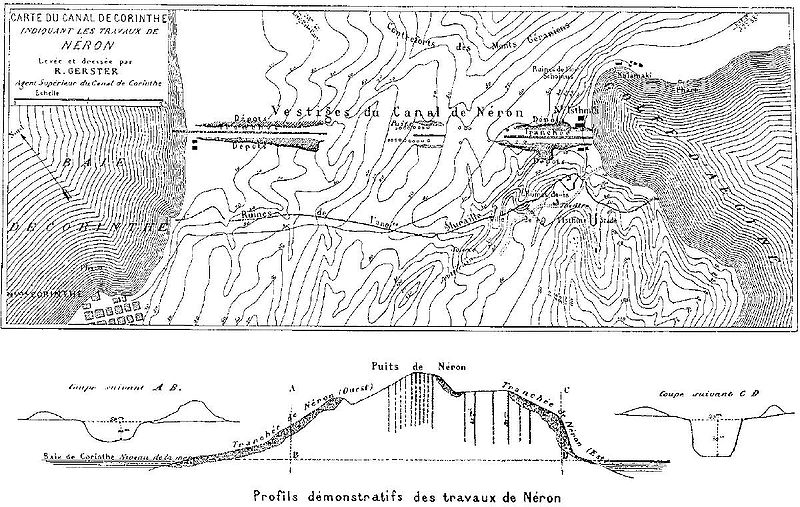
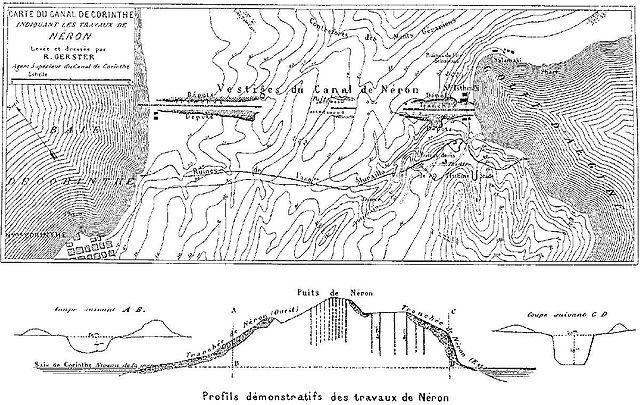
Deutsch: Überreste von Neros Projekt, einen Kanal durch den Isthmus von Korinth zu stechen (67 n. Chr.). Die dunkel schraffierten Bereiche markieren die antiken Aushubarbeiten. Die senkrechten Schächte im Bild unten dienten den Römern zur Begutachtung des Steinmaterials in der Tiefe. Die Karte wurde vom Chefingenieur des modernen Kanalprojekts Bela Gerster 1881 bei der Erkundung der Landenge angefertigt.
English: Remains of Nero's aborted project to cut through the Isthmus of Corinth (67 AD). The Roman digging is indicated by the dark shaded areas. The vertical shafts in the cross section below were excavated by the Romans to probe the stone material. The map was drawn by chief engineer Bela Gerster in 1881 during his survey for the modern canal. |
| Дата | |
| Източник | Werner, Walter: "The largest ship trackway in ancient times: the Diolkos of the Isthmus of Corinth, Greece, and early attempts to build a canal", The International Journal of Nautical Archaeology, Vol. 26, No. 2 (1997), pp. 98–119 (114, Fig. 25) |
| Автор | Bela Gerster (1850–1923) |
| други версии |
.jpg)

|
Това изображение (или всички изображения в тази страница/категория) би трябвало да бъдат пресъздадени с използване на векторна графика във формат SVG. Това има няколко предимства; вижте Commons:Media for cleanup за повече информация. Ако разполагате с това избражение в SVG формат, моля качете го. След това заместете този шаблон с {{Vector version available|име на новия файл.svg}}.
|


Лицензиране
|
Това произведение е обществено достояние в държавите, в които срокът на авторското право е 100 години или по-малко след смъртта на автора. Това произведение е обществено достояние в Съединените американски щати, защото е било публикувано преди 1 януари 1929 година. | |
| This file has been identified as being free of known restrictions under copyright law, including all related and neighboring rights. | |
История на файла
Избирането на дата/час ще покаже как е изглеждал файлът към онзи момент.
| Дата/Час | Миникартинка | Размер | Потребител | Коментар | |
|---|---|---|---|---|---|
| текуща | 16:46, 15 януари 2008 | | 1200 × 760 (225 КБ) | Gun Powder Ma | == Summary == {{Information |Description= {{de| Überreste von Neros Projekt, einen Kanal durch den Isthmus von Korinth zu stechen. Die Karte wurde vom Chefingenieur des modernen Kanalprojekts Bela Gerster 1881 bei der Erkundung der Landenge gezeichnet. D |
| 16:38, 15 януари 2008 |  | 751 × 476 (102 КБ) | Gun Powder Ma | {{Information |Description= {{de| Überreste von Neros Projekt, einen Kanal durch den Isthmus von Korinth zu stechen. Die Karte wurde vom Chefingenieur des modernen Kanalprojekts Bela Gerster 1881 bei der Erkundung der Landenge gezeichnet. Die senkrechten |
Използване на файла
Следната страница използва следния файл:
Глобално използване на файл
Този файл се използва от следните други уикита:
- Употреба в als.wikipedia.org
- Употреба в az.wikipedia.org
- Употреба в be.wikipedia.org
- Употреба в da.wikipedia.org
- Употреба в de.wikipedia.org
- Употреба в en.wikipedia.org
- Употреба в es.wikipedia.org
- Употреба в et.wikipedia.org
- Употреба в fi.wikipedia.org
- Употреба в fr.wikipedia.org
- Употреба в hyw.wikipedia.org
- Употреба в it.wikipedia.org
- Употреба в nn.wikipedia.org
- Употреба в no.wikipedia.org
- Употреба в ro.wikipedia.org
- Употреба в ru.wikipedia.org
- Употреба в sk.wikipedia.org
- Употреба в sl.wikipedia.org
- Употреба в sq.wikipedia.org
- Употреба в sv.wikipedia.org
- Употреба в tr.wikipedia.org
- Употреба в uk.wikipedia.org
- Употреба в vi.wikipedia.org