
Файл:Gulf of Izmit, Turkey.JPG

Размер на този преглед: 800 × 532 пиксела. Други разделителни способности: 320 × 213 пиксела | 640 × 425 пиксела | 1024 × 681 пиксела | 1280 × 851 пиксела | 2560 × 1701 пиксела | 4288 × 2850 пиксела.
Оригинален файл (4288 × 2850 пиксела, големина на файла: 2,6 МБ, MIME-тип: image/jpeg)
| Този файл е от Общомедия и може да се използва от други проекти.
Следва информация за файла, достъпна през оригиналната му описателна страница. |
Резюме
| Описание |
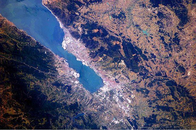
English: This astronaut photograph highlights the metropolitan area of Izmit along the northern and eastern shores of the Sea of Marmara, at the end of the Gulf of Izmit. Commercial and industrial centres—including petroleum refineries and automobile factories—are recognizable by large structures with white rooftops. The smaller city of Gölcük on the southern shoreline of the Gulf is the location of a Turkish naval facility and another automobile factory. Both urban areas are built primarily on flat lowlands adjacent to the Gulf, with green vegetation marking highland areas to the north of Izmit and south of Gölcük. |
| Дата | |
| Източник | NASA Earth Observatory |
| Автор | ISS Expedition 24 crew |
| Camera location | | View this and other nearby images on: OpenStreetMap |
|---|
Тази картинка е каталогизирина от Космическия център „Джонсън“ към НАСА с идентификационен номер (Photo ID): ISS024-E-10162. Този етикет не посочва статуса около авторското право към прикачената творба. Изисква се нормален етикет за авторско право. Вижте Общомедия:Лицензиране за повече информация. Други езици:
|
Image acquired with a Nikon D2Xs digital camera using a 180 mm lens, and is provided by the ISS Crew Earth Observations experiment and Image Science & Analysis Laboratory, Johnson Space Center.
Лицензиране
| This file is in the public domain in the United States because it was solely created by NASA. NASA copyright policy states that "NASA material is not protected by copyright unless noted". (See Template:PD-USGov, NASA copyright policy page or JPL Image Use Policy.) | ||
 |
Warnings:
|
История на файла
Избирането на дата/час ще покаже как е изглеждал файлът към онзи момент.
| Дата/Час | Миникартинка | Размер | Потребител | Коментар | |
|---|---|---|---|---|---|
| текуща | 09:56, 23 август 2010 | | 4288 × 2850 (2,6 МБ) | Originalwana | {{Information |Description={{en|1=This astronaut photograph highlights the metropolitan area of Izmit along the northern and eastern shores of the Sea of Marmara, at the end of the Gulf of Izmit. [[:Category:Commerc |
Използване на файла
Следната страница използва следния файл:
Глобално използване на файл
Този файл се използва от следните други уикита:
- Употреба в ar.wikipedia.org
- Употреба в az.wikipedia.org
- Употреба в ba.wikipedia.org
- Употреба в bn.wikipedia.org
- Употреба в ca.wikipedia.org
- Употреба в ceb.wikipedia.org
- Употреба в cs.wikipedia.org
- Употреба в en.wikipedia.org
- Употреба в es.wikipedia.org
- Употреба в eu.wikipedia.org
- Употреба в fa.wikipedia.org
- Употреба в fr.wikipedia.org
- Употреба в he.wikipedia.org
- Употреба в hr.wikipedia.org
- Употреба в id.wikipedia.org
- Употреба в ilo.wikipedia.org
- Употреба в it.wikipedia.org
- Употреба в ka.wikipedia.org
- Употреба в mt.wikipedia.org
- Употреба в nl.wikipedia.org
- Употреба в nn.wikipedia.org
- Употреба в ru.wikipedia.org
- Употреба в tr.wikipedia.org
- Употреба в tr.wikivoyage.org
- Употреба в www.wikidata.org
- Употреба в zh.wikipedia.org