
Файл:First Republic of Armenia in 1918-1920.png

Размер на този преглед: 799 × 348 пиксела. Други разделителни способности: 320 × 139 пиксела | 640 × 279 пиксела | 1024 × 446 пиксела | 1280 × 558 пиксела | 2560 × 1115 пиксела | 8192 × 3568 пиксела.
Оригинален файл (8192 × 3568 пиксела, големина на файла: 14,85 МБ, MIME-тип: image/png)
| Този файл е от Общомедия и може да се използва от други проекти.
Следва информация за файла, достъпна през оригиналната му описателна страница. |
Резюме
| Описание |
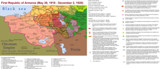
English: The First Republic of Armenia in 1918-1920. |
| Дата | |
| Източник | Собствена творба |
| Автор | Accipite7 |
Лицензиране
Аз, носителят на авторските права над тази творба, я публикувам тук под следния лиценз:
This file is licensed under the Creative Commons Attribution-Share Alike 4.0 International license.
- Можете свободно:
- да споделяте – да копирате, разпространявате и излъчвате произведението
- да ремиксирате – да адаптирате произведението
- Съгласно следните условия:
- признание на авторството – Трябва да посочите авторството, да добавите връзка към лиценза и да посочите дали са правени промени. Можете да направите това по всякакъв разумен начин, но не и по начин, оставящ впечатлението, че същият/същите подкрепят вас или използването по някакъв начин на творбата от вас.
- споделяне на споделеното – В случай, че промените, видоизмените или използвайки като основа произведението, го надградите, то полученото производно произведение може да се разпространява само съгласно условията на същия или съвместим лиценз с оригиналния такъв.
История на файла
Избирането на дата/час ще покаже как е изглеждал файлът към онзи момент.
| Дата/Час | Миникартинка | Размер | Потребител | Коментар | |
|---|---|---|---|---|---|
| текуща | 15:13, 2 юни 2021 | | 8192 × 3568 (14,85 МБ) | Accipite7 | for the convenience of viewing small details, the size is increased, the colors are improved |
| 08:17, 25 май 2021 |  | 4096 × 1784 (3,69 МБ) | Accipite7 | The border between Nahang of Shirak and Nahang of Syunik has been clarified. | |
| 09:59, 21 май 2021 |  | 4096 × 1784 (3,7 МБ) | Accipite7 | The temporary border between the Republic of Armenia and the Soviet republics (August 10, 1920) in the Nakhichevan county has been clarified. Added a legend marked on the map under the number 26. | |
| 08:35, 13 май 2021 |  | 4096 × 1784 (3,97 МБ) | Accipite7 | fixed typo | |
| 08:27, 13 май 2021 |  | 4096 × 1784 (3,97 МБ) | Accipite7 | The names of the types of administrative units of the former Russian Empire have been clarified: uyezd = county, okrug = district, oblast = territory, guberniya = governorate. | |
| 11:14, 12 май 2021 |  | 4096 × 1784 (3,71 МБ) | Accipite7 | Corrected data in the map legend regarding what is indicated on the map by numbers. Clarified the boundaries of the territories required at the Paris Peace Conference. I strongly ask the user of Culminatio not to vandalize and not return the map to the version on which he marked the line reached as a result of the Turkish offensive in 1920. Since, firstly, it is neural: Batumi, Artvin and Ardahan were under the control of the Democratic Republic of Georgia until February-March 1921. And secon... | |
| 04:13, 12 май 2021 |  | 5375 × 2341 (7,18 МБ) | Culminatio | Reverted to version as of 15:05, 8 May 2021 (UTC) | |
| 07:11, 11 май 2021 |  | 4096 × 1784 (3,99 МБ) | Accipite7 | The boundaries of the territory of the demands of the Armenian delegation in the Transcaucasus, submitted to the Paris Peace Conference of 1919, were clarified. There is no need to overload the map with the line reached by the Turkish forces in 1920, as the map already shows the results of the Armenian-Turkish war of 1920 - the border according to the Treaty of Alexandropol, December 2, 1920 | |
| 15:05, 8 май 2021 |  | 5375 × 2341 (7,18 МБ) | Culminatio | Additional line of the turkish advance on the northern positions during the war of 1920. Additional numbers 10,19,20,21 on the map. | |
| 10:49, 8 май 2021 |  | 6336 × 2760 (2,21 МБ) | Accipite7 | Improved colors. |
Използване на файла
Следната страница използва следния файл:
Глобално използване на файл
Този файл се използва от следните други уикита:
- Употреба в az.wikipedia.org
- Употреба в be.wikipedia.org
- Употреба в de.wikipedia.org
- Употреба в el.wikipedia.org
- Употреба в fi.wikipedia.org
- Употреба в fr.wikipedia.org
- Употреба в hy.wikipedia.org
- Употреба в it.wikipedia.org
- Употреба в nl.wikipedia.org
- Употреба в pl.wikipedia.org
- Употреба в pt.wikipedia.org
- Употреба в ro.wikipedia.org
- Употреба в ru.wikipedia.org
- Употреба в sr.wikipedia.org
- Употреба в uk.wikipedia.org
- Употреба в zh.wikipedia.org