
Файл:Daventry UK locator map.svg

Размер на този PNG предварителен преглед на изходния SVG файл: 524 × 600 пиксела. Други разделителни способности: 210 × 240 пиксела | 419 × 480 пиксела | 671 × 768 пиксела | 895 × 1024 пиксела | 1789 × 2048 пиксела | 1106 × 1266 пиксела.
Оригинален файл (Файл във формат SVG, основен размер: 1106 × 1266 пиксела, големина на файла: 995 КБ)
| Този файл е от Общомедия и може да се използва от други проекти.
Следва информация за файла, достъпна през оригиналната му описателна страница. |
| Описание |
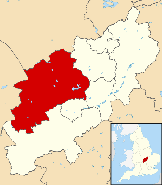
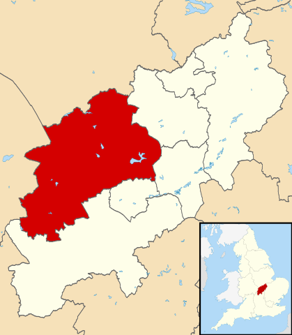
Map of Northamptonshire, UK with Daventry highlighted. Equirectangular map projection on WGS 84 datum, with N/S stretched 160% |
| Дата | |
| Източник |
|
| Автор | Nilfanion, created using Ordnance Survey data |
| Права (Повторно използване на файла) |
Този файл се разпространява под лиценз Криейтив Комънс Признание — Споделяне на споделеното 3.0. Признание: Contains Ordnance Survey data © Crown copyright and database right
|
История на файла
Избирането на дата/час ще покаже как е изглеждал файлът към онзи момент.
| Дата/Час | Миникартинка | Размер | Потребител | Коментар | |
|---|---|---|---|---|---|
| текуща | 22:13, 13 август 2011 | | 1106 × 1266 (995 КБ) | Nilfanion | {{Information |Description=Map of Northamptonshire, UK with Daventry highlighted. Equirectangular map projection on WGS 84 datum, with N/S stretched 160% |Source=Ordnance Survey [http |
Използване на файла
Следната страница използва следния файл:
Глобално използване на файл
Този файл се използва от следните други уикита:
- Употреба в cy.wikipedia.org
- Употреба в en.wikipedia.org
- Long Buckby
- Braunston
- Naseby
- Daventry
- Althorp
- Daventry District
- East Farndon
- Welford, Northamptonshire
- Crick, Northamptonshire
- Arthingworth
- Ashby St Ledgers
- Badby
- Barby, Northamptonshire
- Boughton, Northamptonshire
- Woodford Halse
- Brixworth
- Brockhall, Northamptonshire
- Byfield, Northamptonshire
- Canons Ashby
- Watford, Northamptonshire
- Yelvertoft
- Winwick, Northamptonshire
- Whilton
- West Haddon
- Walgrave
- Upper Catesby
- Thornby, Northamptonshire
- Teeton
- Sulby, Northamptonshire
- Church Stowe
- Staverton, Northamptonshire
- Spratton
- Sibbertoft
- Scaldwell
- Ravensthorpe, Northamptonshire
- Preston Capes
- Pitsford
- Overstone, Northamptonshire
- Old, Northamptonshire
- Norton, Northamptonshire
- Newnham, Northamptonshire
- Moulton, Northamptonshire
- Marston Trussell
- Maidwell
- Kilsby
- Lamport, Northamptonshire
- Lilbourne
- Little Brington
- Lower Catesby
Преглед на глобалната употреба на файла.